3D measurement encompasses both the process of capturing the spatial characteristics of structures or environments in three-dimensional form - using technologies such as laser scanning and photogrammetry - and the virtual verification of these dimensions using reality capture data, often facilitated by advanced 3D data management platforms.
As professionals in architecture, engineering, construction (AEC), and manufacturing, you know the value of precision. Accurate measurements mean the difference between efficient processes and costly rework.
As global standards for construction and production grow ever higher, and projects get increasingly more complex, more powerful surveying technology is needed. That’s where advanced 3D measurement technologies come in, offering a new level of detail and accuracy that transforms how we visualize, document, and manage the spaces where we live and work.
The data collected - encompassing the length, height, width, and depth of objects within an environment - can be used to create detailed 2D drawings, 3D models, or even fully realized digital twins. In this article, we’ll explore the key concepts of 3D measurement and the transformative potential that advanced scanning technologies offer to modern industries.
Types of 3D measurement technologies
3D measurement has come a long way from its manual beginnings. Early surveyors relied on tools like rods, chains, compasses, and plumb bobs, combined with extensive handwritten calculations to determine distances. Even today, traditional tools such as calipers, distos, and tape measures remain in use. However, technological advancements have transformed the field.
The introduction of photogrammetry offered a new perspective. A greater revolution followed after 2000 with the rise of lidar scanning, which uses lasers to scan environments and generate vast datasets called "point clouds." These point clouds are the foundation for highly detailed 2D and 3D outputs.
Lidar equipment can cater to various 3D measurement needs. Terrestrial laser scanners (TLS) can be mounted on tripods for stationary setups or used as mobile systems (MTLS or MMS) carried by surveyors or mounted on vehicles. Handheld and wearable devices, such as NavVis VLX and NavVis MLX, combine the benefits of stationary and mobile systems. They capture geo-referenced, photorealistic point clouds and 360° panoramas at walking speed.
To complement this hardware, advanced software platforms like NavVis IVION enable virtual 3D measurements and enhance visualization, analysis, and collaboration.

Benefits of 3D measurement with laser scanners
As one might imagine, traditional tools and manual methods for 3D measurement are often slow, labor-intensive, and require substantial setup time. Modern 3D scanners, however, are designed to capture vastly more data, much faster.
Ease of use is another advantage. Operating a 3D scanner today requires far less specialized knowledge compared to conducting surveys with older, more cumbersome methods.
Additionally, the best scanners are much more than just hardware: they are powered by advanced software algorithms that enhance the capture of spaces, even while in motion. When hardware and software integrat seamlessly, manual effort is greatly reduced, and the risk of errors is minimized. NavVis provides a platform that perfectly complements the scanning process, empowering users to interpret and act on 3D spatial measurements with ease.
Where is laser scanning data used for 3D measurement
In detail or land surveying, lidar scanning data is used to generate highly detailed 2D and 3D measurements and deliverables such as CAD linework, terrain and contour maps, Digital Elevation Models (DEMs), and comprehensive visualizations of streets, buildings, and landscapes.
In the AEC industry, 3D scanning has become a cornerstone of modern project management, enabling detailed capture of pre-existing structures and construction progress and supporting design and construction verification. Renovations and retrofits especially benefit from the ability to take large-scale 3D measurements, allowing professionals to document even the most complex spaces - otherwise difficult to capture manually.
In the manufacturing and process industries, up-to-date digital twins of production facilities enable professionals to enhance planning and operations. Access to trusted as-is documentation and the ability to take 3D virtual measurements - and more - significantly boosts engineering productivity.
How laser scanners enable 3D measurement
Laser scanners emit beams of light that strike the surfaces of objects and environments and reflect back to the scanner, enabling it to calculate the distance to each point with millimeter-level accuracy.
This process generates a 3D cloud of single-point measurements, commonly known as a point cloud - the fundamental data type produced by a lidar sensor. When you have all that data, dimensional measurements (such as length, width, height, and volume) are easy to calculate.
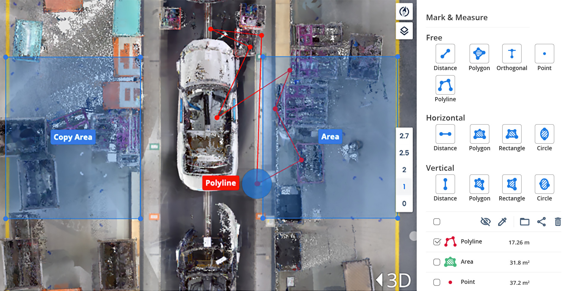
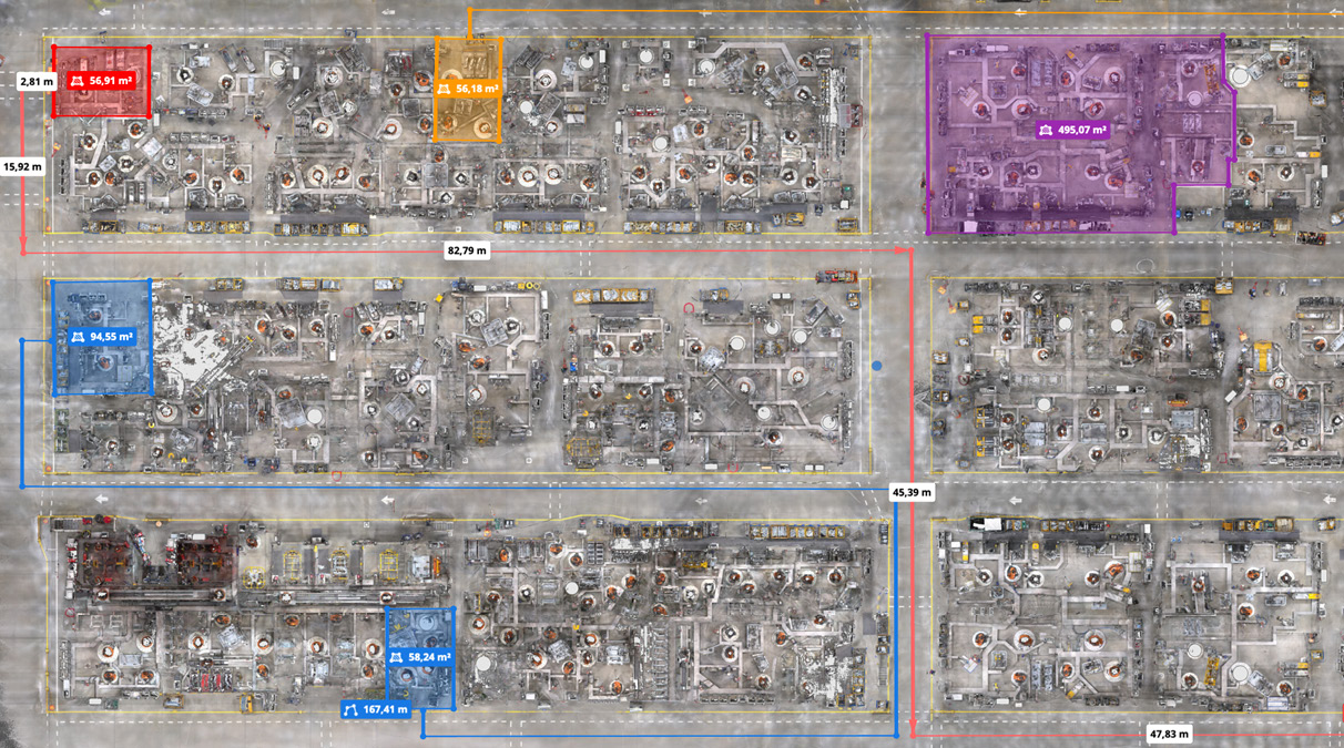
A key feature of NavVis IVION, our cloud-based platform for spatial data management, is the ability to mark and measure specific areas of a point cloud directly in a web browser. Users can take accurate point-to-point measurements, mark up the data to highlight key areas, organize measurements into folders, and share them with all stakeholders.
The video showcases - among other functionalities - the power of the mark and measure feature in NavVis IVION, which enables professionals to extract insights from their digital factory for layout planning and optimizing the flow of goods, ultimately reducing costs and increasing output.
The polyline measurement tool:

The circle measurement tool:

Learn more about how 3D measurements of industrial environments can enhance production workflows:
- Digital factory use case: Factory layout and assembly planning
- Optimizing factory planning in the automotive industry
Combined with innovative 3D laser scanning systems like the NavVis LX-Series, NavVis IVION can transform your projects and operations. Whether you are a construction professional or a factory planner, our experts are here to help you explore the possibilities and find the right 3D measurement solution for your needs.

