
STRABAG revolutionizes surveying with NavVis technology
With NavVis technology, STRABAG is setting new standards in the preservation of evidence and as-built documentation in the construction industry.
Key takeaways
- Eric Skrzeczek's team uses NavVis VLX particularly for the preservation of evidence and as-built documentation of construction sites in civil engineering
- With NavVis VLX, a construction site could be scanned in just two hours versus one day using conventional methods
- NavVis IVION is a useful tool for STRABAG in claim management
- Downtimes and closures of critical traffic junctions could be reduced or even completely avoided
- The team can complete more projects because they can scan faster and more efficiently
STRABAG is one of Europe's largest technology groups for construction services and one of Germany's largest traffic route builders - from rail and road to airport construction. As part of the Lower Saxony/Saxony-Anhalt region, Eric Skrzeczek is responsible for BIM, mobile mapping, laser scanning and GIS.
He discovered NavVis technology through a special project: a large telecommunications company needed to secure evidence, but the team was unable to use their mobile mapping system - a vehicle-mounted surveying system - to survey the access paths. To avoid this problem in future projects, the company started looking for a new mobile mapping system.
.jpg?width=300&name=Punktwolke%20mit%20Extraktion%20(1).jpg)
Proof of Concept
To test whether NavVis VLX would really be suitable for STRABAG's projects, Giath Askoul from STRABAG Innovation and Digitalization put the device to the test in a proof of concept. One of the tests was carried out with the team from the Lower Saxony / Saxony-Anhalt region, where terrain was scanned that would usually pose a problem for other SLAM-based systems.
The results spoke for themselves: “The scanning was incredibly fast. The data we got was really good.”
Another advantage of NavVis VLX compared to their previously used system is the reduced volume of data, which results in shorter processing times and less computing capacity required.
Before making the final decision, the team tested another mobile mapping system on the same route, but noticed a significant height deviation and drift in the data, which is why they opted for NavVis VLX. “We were absolutely delighted with NavVis VLX and wanted to get the device as soon as possible,” says Eric Skrzeczek.
Want to learn more about how you can optimize your surveying workflows with 3D laser scanning?
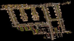
Preservation of evidence and claim management
Eric Skrzeczek's team is deployed in particular for the preservation of evidence and documentation of STRABAG construction sites in civil engineering. Approximately one week before construction begins on a project, the team is notified of the specific area on the construction site where evidence preservation is needed and promptly carries out the required work. Once the construction work has been completed, the same area is surveyed again. With NavVis VLX, up to 12 streets can be surveyed in a single day, with the team setting up 3 control points for each street. That's quite impressive. We could probably do even more, but we only have three battery packs,” says Eric Skrzeczek.
Eric Skrzeczek sees the main application in the creation of as-built documentation as well as billing and boundary plans: “We also carry out classic surveying tasks, and we can do this much faster with the device.” He is also impressed by the data quality of the point cloud. Thanks to the high point density, once the data has been processed in NavVis IVION, it can be further processed and partially analyzed automatically using additional software. According to Eric Skrzeczek, the software recognizes broken edges in NavVis data - such as curbs or buildings - very quickly, around 50-100 m of route data in just a few seconds.
NavVis technology has also proven to be valuable for claim management. The STRABAG team can upload the scan of the construction site in question to NavVis IVION before the start of construction work and make it available to the project management via a link. Any complaints or compensation claims, for example in the event of damage to private property, can be checked quickly and reliably using the captured panoramic images without having to involve the company's legal department for each case.

Reduced downtime
Surveying work using conventional methods is particularly difficult at complex traffic junctions. In most cases, the areas in question have to be blocked off extensively to enable surveyors to collect the desired data. However, this inevitably results in road traffic obstructions, project delays, and increased costs. With NavVis VLX, however, such downtimes can be reduced or even avoided altogether, as the device not only scans extremely quickly, but also very flexibly.
The scanning of a junction, for example - normally associated with costly road closures - can be completed conveniently with the wearable laser scanning system within a very short period of time and without restricting traffic. This eliminates the costs of road closures and additional traffic safety measures in particular. Eric Skrzeczek and his team were able to scan a large intersection, which also included a tram line and a bridge, in just two hours. “This allows us to shorten closure times, which of course also makes out client happy. This is also a point where we can set ourselves apart from other companies,” says Eric Skrzeczek.
Free passage to uncomplicated surveying
For many companies in the surveying field, supporting their employees as efficiently as possible can be a challenge, and STRABAG is no exception: “We have a lot of employees who do an amazing job, but of course they can't cover everything,” says Eric Skrzeczek. NavVis VLX offers twofold relief here: Firstly, existing employees can scan much faster and thus complete more projects in less time. Secondly, the device's user-friendliness means that new employees can be trained quickly and put to productive use thanks to its low level of complexity. “We quickly realized how easy the device is to use. In principle, it's just a few clicks and everything else is shown on the display.” He also appreciates the fact that the device automatically stops recording and shuts down when the battery is low, so there is no need to worry about losing an entire data set.
Eric Skrzeczek is also impressed with NavVis IVION: “We are very satisfied with the NavVis IVION platform. It can be used by virtually anyone.” He also appreciates the processing in the cloud, which not only saves an enormous amount of time during data processing, but also allows him to start data processing from any location. The recorded data can be uploaded directly from the construction site and is already fully processed when he returns to the office.
For a separate infrastructure project, NavVis VLX was used side by side with other surveying methods: While the roadway could be surveyed using a vehicle-mounted system, the adjacent footpath - cordoned off with several barricades - was inaccessible by vehicle. The bridge, including the sidewalk, was then surveyed again with NavVis VLX: “It worked really well and the data also matched perfectly.” Small areas under the bridge that were not accessible on foot due to the river running underneath were then measured with a total station.
NavVis VLX has now become an integral part of Eric Skrzeczek's surveying team's toolkit. Convinced by the speed and accuracy of the device, it has already been demonstrated to numerous other teams in the company and will continue to support STRABAG in revolutionizing surveying.

Next generation 3D laser scanning is here
Wearable, 3D laser scanning devices are faster and more scalable than ever before, providing survey-level data quality for even the most demanding projects.
Find out how our entire reality capture solution can benefit your scan-to-BIM workflows by chatting with one of our experts: