
NavVis Reality Capture Service - Enterprise
Designed for large enterprises: Effortless global reality capture services tailored to your project needs.
NavVis Reality Capture Service – Enterprise
Reality capture technology has become more accessible, but not every enterprise is ready to adopt it in-house.
That’s where our reality capture services come in. Designed for large enterprises with facilities around the world, we act as your general contractor and coordinator, managing the entire process—from scanning and data processing to re-scanning—while leveraging our global network of trusted surveying and reality capture partners. This approach ensures you receive precise, up-to-date spatial data without the need for internal resources, making reality capture and digital twin implementation seamless and hassle-free.
Trusted by

Seamlessly integrated:
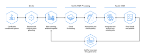
How our Reality Capture Service fits into your process
What makes NavVis Reality Capture Service – Enterprise unique?
Complete project management and support
We handle every aspect of your reality capture project from start to finish, with expert support at every step to ensure smooth delivery and optimal results.
Data processing and quality control service by technology experts
We convert large-scale scan data into ready-to-use digital assets with automated privacy controls, geo-registration, and control point validation for fast, reliable results. This process is handled by NavVis’ own technology experts or trusted surveying and laser scanning professionals, ensuring the highest quality through NavVis’ oversight.
Global network
We act as your single point of contact and general contractor, simplifying the process to ensure efficient, consistent, and high-quality data capture and delivery across your facilities worldwide. Leveraging our extensive global network of experienced surveying and reality capture companies, we coordinate every aspect of the project—ensuring seamless execution while benefiting from the expertise of our trusted partners.

Reality capture service for large enterprises:
Speed, efficiency and assured quality

For enterprises managing multiple locations, the quick turnaround of our reality capture service allows for faster project execution and quicker access to actionable insights.
Enterprises can rely on our expert reality capture service, eliminating the need to build and maintain internal teams or coordinate with multiple global providers, simplifying operations and freeing up valuable resources.
Our reality capture service ensures consistent, high-quality results across multiple sites, with expert quality control, leveraging deep knowledge of the technology and best practices at every step.
Why choose NavVis services?

With years of experience in reality capture and digital twin solutions, we’ve helped enterprises around the world unlock the value of spatial data.

Our network of scanning partners spans the globe, ensuring your project can scale no matter where it’s located.
NavVis is ready to start immediately, and with our global partner network, we can capture data from multiple facilities simultaneously, ensuring fast and efficient delivery.