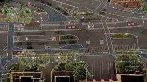
Environment: Urban road - Los Angeles, USA
Download a sample of NavVis VLX 3 point cloud data in .e57 format and the results of the topographic survey in .dxf and .dwg formats.
About the project
Denn Engineers, a top US surveying firm, tested NavVis technology against traditional survey methods in a complex urban area. The goal was to evaluate the speed, completeness, and accuracy of the data acquisition and processing using NavVis technology.
Using the NavVis VLX 3 3D wearable laser scanner, they quickly scanned the entire site despite obstacles like traffic and poor weather conditions, achieving in record time what traditional methods could only do for a tenth of the area. The NavVis workflow reduced human errors and obstructions, ensuring swift and comprehensive data collection without sacrificing accuracy.
Denn Engineers established a control network for precise linework coding and integrated it during processing with NavVis IVION for further accurate automated feature extraction. The results could be used for ADA compliance, civil design, and curb and surface analysis.
The results of the topographic as-built road survey can be downloaded below and will include point cloud data in .e57, CAD in .dwg and .dxf (link to point cloud9 as well as site details and a topographic survey workflow comparison.
The linework and CAD work on the NavVis data was carried out in record time by Exedra BIM.
Site details:
- Size: 38,000 sqm / 409,000 sq ft
- Scanning time: 108 minutes
- Project type: Topographic as-built road survey

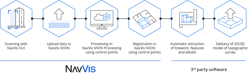
NavVis optimizes your topographic surveying workflows.
The NavVis workflow starts by scanning with NavVis LX-Series, then uploading the data to NavVis IVION Processing for processing and verification, and finally working with the point cloud data in NavVis IVION or 3rd party tools. Find out more about the NavVis workflow below:
"Having the .e57 from NavVis VLX customers allowed us to outline a simple workflow for creating 3D topographic deliverables. The first step is to convert the data into .dot files with a few clicks in TopoDOT. We then start creating the linework and the assets to be digitized. The automated and semi-automated extraction functions offered by TopoDOT are very good, especially for elements such as curbs, road markings, signs, transmission lines, and the like. However, the whole process becomes smoother by displaying the site photos in NavVis IVION on a second screen. You can instantly check the data and images together. The platform works just like Google Maps: the project is easy to navigate, and the fact that we do not have to host large amounts of images on our server (unlike other software solutions) is a significant advantage."