

.jpg?width=300&name=250212-IVION-Core-Website_Hero%20(1).jpg)
NavVis IVION Core
Add more value to buildings and assets
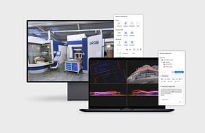
A reality capture platform for surveying, laser scanning, and AEC professionals. Manage your 3D scan data with intuitive tools for creation, collaboration, and publication. NavVis IVION Core makes mobile mapping workflows more efficient, speeds up model creation and delivery, and adds value to your data.
Already a customer? Log in now


Why NavVis IVION Core?
The need for high-end computers, specialist software and technical skills can limit reality capture data to select individuals. With NavVis IVION Core, point clouds and panoramic images are transformed into intelligent spaces which are accessible to every stakeholder from any standard web browser.
- Efficiently process, register, publish, and deliver your scan data online
- Rescan with confidence knowing that only the best quality data will automatically be shown
- Inspect, plan and measure with a building visualization that's easy to navigate
- Improve efficiency by giving your team and clients access to the full point cloud data from anywhere
- Optimize scan-to-BIM workflows and boost verification efficiency
- Go beyond modeling and offer your clients even more value with a new kind of deliverable that extends the use of 3D scan data
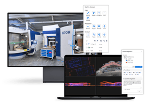

Simplify your workflow with our model import and visualization solution, which enables seamless visual comparisons between 3D models and point clouds. With support for predefined coordinate systems, the platform ensures precise and convenient model alignment, streamlining your verification process. Evaluate BIM models of existing conditions and design proposals against the as-built state, validate IFC models with ease, and annotate issues directly within the platform—eliminating the need for third-party software.
Point Cloud Cleanup is a manual tool in NavVis IVION that allows users to remove unwanted points while maintaining consistency with panoramic images. Easily eliminate extraneous points, such as reflections, spray artifacts, and moving objects, without relying on external software. This intuitive integration preserves panoramic imagery, ensuring precision and efficiency without disrupting your workflow. No more tedious exporting and re-importing or risking data integrity—refine your point clouds effortlessly in one smooth process.
Give your customers an entirely new way to use and interact with floor plans. NavVis IVION Core automatically generates an AI-based map to give an overview of the entire site. Upload custom maps that have been designed in photo editing software.

360° immersive images are more than just digital pictures—they’re enriched with laser scan data, allowing you to interact with scanned spaces as if you were onsite. Easily measure distances, organize images into folders, and export them in multiple file formats for use in third-party solutions. With Mark & Measure, you can effortlessly share point-to-point measurements, view precise coordinate information, and take point and orthogonal measurements for enhanced accuracy.

NavVis IVION Core allows users to download sections of a point cloud in different file formats, so you can edit your point clouds and import them into other software programs. Make a selection in the point cloud with the 3D crop box to only download what you need.

Align and register of all your NavVis scans as well as scans from third party devices. This feature includes the ability to perform automatic cloud to cloud alignment.

Access all of your projects from one account. Easily switch between and search for sites from a central dashboard. Each site has a unique website address and user permissions giving you complete control over site usage.

Visually inspect point clouds using multiple 2D views and slices of the the 3D scene. These interactive views provide users with the ability to assess the quality of the point cloud and identify incorrect registrations.

Using a web browser, NavVis IVION Core simplifies publishing and sharing scan data. Just send a link to publish and share scans or send a deep link to specific content or a location within the scan. No downloads, plug-ins or desktop software required.

Enter the latitude and longitude or a custom spatial reference system, allowing for survey-grade geo-registration of data. Selecting your own site coordinate system also ensures that your data is aligned to the exact location of your site, making it easier and faster to upload and download data.
Whether you're using static laser scanners, drones or NavVis VLX, you can upload and combine datasets in NavVis IVION Core and publish the scans as a link. For structured E57 files, you can automatically convert point clouds into immersive 360° images with full NavVis IVION Core functionality.

NavVis IVION Core features an easy to use, scalable content management system for adding geo-tagged information and media to 3D scans. Users can right-click anywhere on the screen to add and view this information as points of interest. The powerful search function makes it easy for users to find the information they need.

Rescan with confidence knowing that only the best quality data from overlapping datasets will be shown in NavVis IVION. Proprietary algorithms select data based on the date of the scan, the distance from the scanner and the density of the point cloud enabling you to focus on what needs to be scanned and not on the underlying datasets.
.png?width=64&name=Data-Workflow-Management%20(1).png)
Streamline operations by enabling users to work simultaneously within the same site. Data admins can seamlessly manage and update new data, while at the same time, end users can continue working using the most recently published version. This simplified workflow centralizes data management without disrupting end users.
Seamlessly integrate your site with the digital world using NavVis IVION Go, the mobile app companion to NavVis IVION that enables you to synchronize information and tasks with their physical context and location.
With NavVis IVION Go, you can log observations, issues, and best practices during your regular inspections, then share, discuss and track progress with your colleagues.
- Increase team productivity with contextual digital annotations
- Access information within the context of your location inside the site, and switch between 3D panoramas and 2D floorplan views
- No special infrastructure or hardware required — all you need is an Android or iOS device

iOS & Android
Download the app
![]()
![]()
Post-processing in the cloud
With NavVis IVION Processing you can process laser scan data captured by NavVis devices anywhere with an internet connection. Easily set up and start processing multiple datasets onsite, ready for when you’re back to the office.

NavVis IVION Core resources


-2.jpeg?width=300&name=NavVis-LSP_background%20(1)-2.jpeg)